Cycling in Manchester With Journey Times Based Around Metrolink Routes
We Upgraded the Metrolink Tram Map
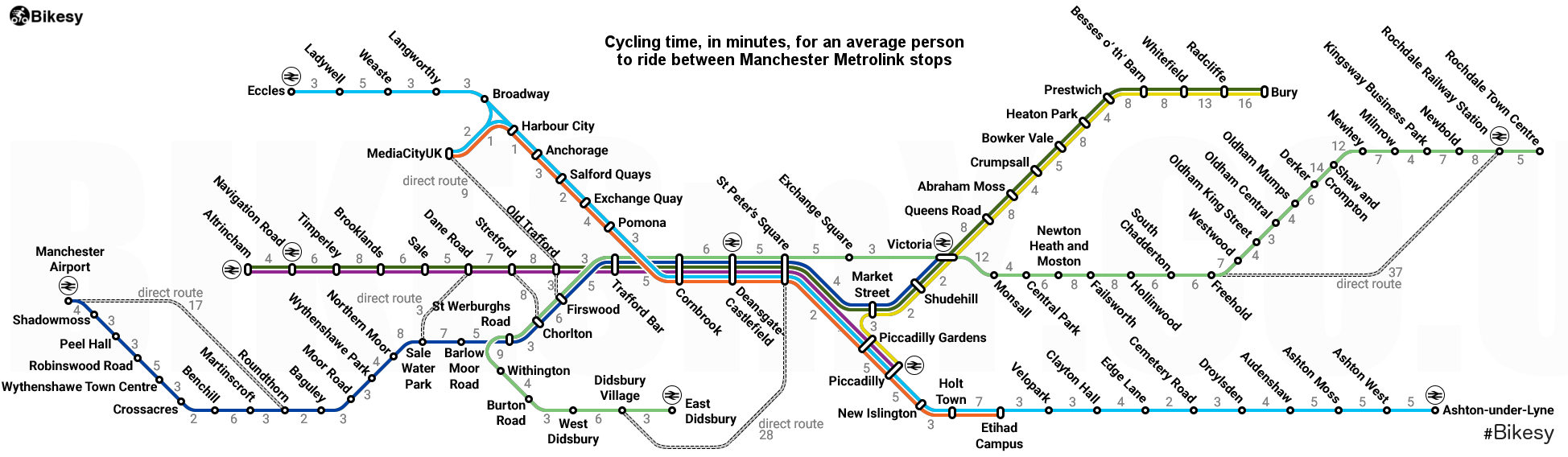
We made a few changes to the Metrolink map that lets people know the cycling times between each tram stop so that you can find the fastest way to work or wherever else you want to go.
The map shows the current Metrolink stops using the familiar map design but with the addition of the time it would take in minutes between each stop
If you want to work out how long it would go from one stop to another is easy, just add up the individual minutes and you'll have a good idea of how long the journey would take you by bicycle.
(Click map to enlarge)
Share this Map On Your Site
Want to use this map on your website or blog? Help yourselves, but please link back to the original on this page
How long does it take to cycle between popular spots in Manchester?
A lot of people wonder exactly how long it would take to get to their regular destinations by bike in Manchester, and are often surprised at how little time it takes.
Currently, there are 250 million car journeys of less than one kilometre made each year in Greater Manchester, which is about the equivalent of a five minute bike ride, so we wanted to show people a simple way of understanding just how quickly you can arrive at your destination if you take a bicycle
We set about researching the journey times, for an average adult, to cycle between each tram stop on the Metrolink network and then overlayed that cycling data with a version of the existing, recognisable Manchester Metrolink map.
We were pleasantly surprised at how quick some of the journeys are e.g. Monsall to Victoria Station is a leisurely twelve minute ride by bike while Media City to Deansgate is just a twenty minute spin.
Given that congestion is currently costing businesses in Greater Manchester an estimated £1.3Billion annually, as well as the population of Manchester suffering with the same air quality issues and obesity related illnesses as other cities in the UK, any way of showing people how easy it is to use a bicycle for their regular transportation is something to be encouraged
With the surprisingly large health benefits of local leisurely cycling, and not to mention how expensive driving and parking can be around Manchester, it makes sense to see if travelling by bike is a viable alternative for local journeys
With the exciting new Beelines cycling routes planned by Transport for Greater Manchester we expect some of the new routes to reduce cycle times even more so we'll do another version of this map when the new routes are built to compare the differences.
Have you got friends thinking about getting a bike and riding in Manchester? Share this with them and let them know how quick and easy their journey could be.